
Typically this is 155 to 170 knots maximum sustained winds — and aircraft recon has found 150 knots or 175 mph, so just below the expected value from Dvorak technique.
- Landfall: NHC Track over / through Jamaica near Black River Landfall: NHC Track over / through Jamaica near Black River
WHEN: Early morning Tuesday (~8 AM ET) - The latest NHC forecast is not a good look for Jamaica. Melissa is expected to become a dangerous, category four hurricane early next week just south of the island with 145 mph winds. Due to Melissa’s slow motion, the risk of a prolonged multi-day period of potentially damaging winds, heavy rainfall resulting in life-threatening flash flooding and numerous landslides, and storm surge continues to increase for Jamaica.
- Prepare: Preparations to protect life and property should be rushed to completion.

- A deep upper trough over the eastern U.S. will take Melissa northeast by the end of next week; it is not expected to enter the Gulf.

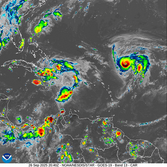
- Humberto and Imelda: Two Major Atlantic Hurricanes in Rare Fujiwhara Effect
- Don't forget that 2024 had a slow start: — the season started off slow but picked up into mid-September with multiple significant hurricanes. Since ocean temperatures are cooler this year, We expect “average” rather than above average activity to finish up the season.
🌀2025 Hurricane Season Updates:
- Forecast Updates
- Tropical Storm Names
- Could a New Google AI Model Be Foretelling the Path of the First Hurricane of 2025?
- How Many Lives Have Been Saved By Improved Hurricane Forecasts?
Quietest Peak Season since 1939!
We’re experiencing the quietest peak of a hurricane season in our lifetime. The Atlantic hasn’t had a storm in 18 days. The last time the Atlantic went without a storm from August 28th - September 15th was in 1939.
The Essential Tools for Tracking Tropical Storms
When it comes to monitoring developing tropical storms and hurricanes, there are three essential tools you should use:
Core Tracking Tools
- Forecast Cone (NHC): The National Hurricane Center's cone graphic shows the storm's probable path and potential error range. Remember: impacts can occur outside the cone.
- Satellite Imagery: Provides real-time views of cloud structure and organization, helping identify areas of heavy rain and potential intensification.
- Radar: Offers detailed precipitation intensity data and helps pinpoint a storm's center, especially crucial as it approaches land.
Specialized Analysis Tools
- Wind Speed Probabilities: Shows likelihood of tropical storm/hurricane-force winds at specific locations.
- Storm Surge Maps: Critical for coastal residents, displaying flood risk areas from ocean inundation.
- Spaghetti Models: Visualize forecast uncertainty through multiple model tracks.
Atlantic Tropical Weather Outlook
No Current Tropical Activity
There are currently no active tropical systems in the Atlantic basin.
Get notified when new storms form: