
Atlantic Fujiwhara Hurricane Records Comparison 2025: Could Humberto and Imelda Dance?
The 2025 Atlantic hurricane season has already been one for the record books, and now a potential Fujiwhara interaction between Hurricane Humberto and Tropical Disturbance 94L (likely to become Tropical Storm or Hurricane Imelda) has caught the attention of meteorologists and storm-watchers alike. While rare, this phenomenon—where two tropical cyclones orbit each other like celestial bodies—has precedent in Atlantic hurricane history. Here’s the science, the historical records, and the latest forecast data.

What Is the Fujiwhara Effect?
The Fujiwhara Effect, first described by Japanese meteorologist Sakuhei Fujiwhara in 1921, occurs when two cyclones within roughly 900–1,200 km of each other begin to rotate counterclockwise around a common axis. Possible outcomes include:

- Mutual orbit until separation
- One storm weakening due to shear from the other
- Complete absorption of the weaker storm into the stronger system
- Importantly: two hurricanes cannot merge into a single “super hurricane.” The dominant storm typically survives while suppressing or absorbing the weaker system.

Fujiwhara effect does not lead to storms “colliding into a monster storm”.
Either they end up deflecting away from each other later on, or if they merge, then one dominates while the other weakens with its remnants absorbed into the larger storm.”
Current 2025 Scenario: Hurricane Humberto and Imelda:
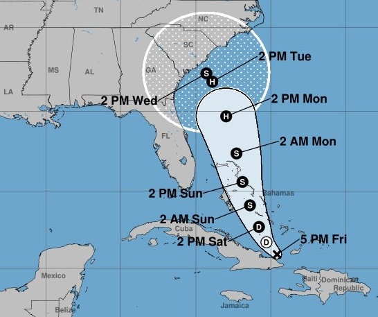
As of September 25, 2025, the situation along the western Atlantic and near the Southeast coast involves two systems of high interest:
Tropical Storm Humberto: Located east of the Bahamas, strengthening, with some models hinting at Category 2+ potential if shear remains low. Disturbance 94L (potential Imelda): Consolidating closer to the Lesser Antilles; models suggest gradual development with a medium-to-high chance of becoming Imelda over the next 48 hours.
Ensemble modeling outputs (GEFS, ECMWF, HWRF): Show significant spread in track forecasts due to storm interaction. Indicate Humberto is likely to become the dominant cyclone, potentially limiting Imelda’s intensity. Suggest risk remains for a close brush along parts of the Southeast U.S. coastline, though absorption of Imelda is a probable outcome.
Key risks at this stage:
High forecast uncertainty due to poor model handling of cyclone interactions.

Enhanced rainfall hazards in the Western Atlantic from broader outflow interactions.
Low (but non-zero) chance of Gulf of America development should Imelda struggle to consolidate near Hispaniola or Cuba.
Historical Atlantic Fujiwhara Records
While the East Pacific has more documented Fujiwhara cases (e.g., Hurricanes Hilary and Irwin in 2017), the Atlantic Basin history is sparse. Still, there are instructive precedents:
Year Storms Involved Fujiwhara/Interaction Outcome Notable Impacts
| Year | Storms Involved | Fujiwhara/Interaction Outcome | Notable Impacts |
|---|---|---|---|
| 1933 | Hurricane #10 (Brownsville Cat 3) & Tropical Storm Florida coast | Simultaneous nearby landfalls, no direct Fujiwhara noted | Texas major landfall; Florida flooding |
| 1959 | Tropical Storm Beulah & unnamed Florida storm | Evidence of interaction in upper-level flows | Mexico and Florida rainfall |
| 1995 | Hurricanes Iris & Humberto with Tropical Storm Karen | Orbited each other in central Atlantic | Minimal U.S. impacts |
| 2005 | Hurricanes Wilma & Alpha | Complex outflow disruptions, partial Fujiwhara | Alpha absorbed into Wilma |
| 2017 (EPAC) | Hilary & Irwin (for comparison) | Classic tight Fujiwhara dance | Historical reference model |
The 2025 record may mark only the second or third documented near-Southeast-coast Fujiwhara—if verified.
Dual Track Map: Modeled ensemble “spaghetti plots” for Humberto and Imelda, with overlap visualization to highlight uncertainty.
Historical Fujiwhara Map: Atlantic Fujiwhara cases marked by storm tracks (1933, 1959, 1995, 2005).
Conclusion
The budding interaction between Hurricane Humberto and Imelda in 2025 could go down as one of the rare Atlantic Fujiwhara hurricane records—a meteorologically significant case study in storm-storm interactions. While this is more a scientific rarity than a multiplying threat, the proximity does increase forecast uncertainty.
Residents near the Southeast U.S. coastline should monitor official NOAA/NHC advisories closely—not for a “superstorm,” but for evolving track and rainfall risks. For the record books, this event underscores just how rare Fujiwhara cases are in the Atlantic, setting 2025 apart as one to study for decades to come.