Less than 3 days out we had nearly 100% agreement on a land falling tropical system into the Carolinas. Enough support that there was a State of Emergency issued ahead of time. Multiple news agency’s began hyping the system and local meteorologists started comparing the system to Helene from last year. Bringing up rain total amounts nearly 70+ hours out. Thankfully, this storm took off the other direction for those who are still recovering from the previous storm impacts. The soon to be #Imelda will get yanked east away from the coast thanks to the upper level influence from Hurricane #Humberto.

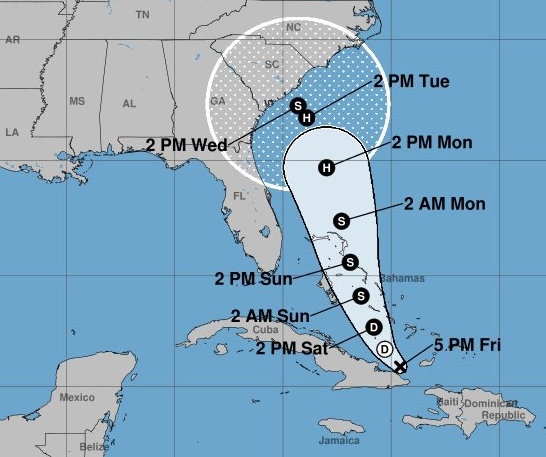
As we approach the final days of September, meteorologists are keeping a close watch on an evolving tropical system — currently known as Potential Tropical Cyclone 9 (PTC 9; formerly Invest 94L) — which is likely to become Tropical Storm or Hurricane Imelda by this weekend. This is a complicated forecast due to the more dominant hurricane Humberto. The system’s track and eventual impacts remain highly uncertain, but early signals point to the potential for an extreme rainfall and flooding event along the Southeast coast.
Hurricane or no hurricane Imelda you are getting RAIN in the Carolinas. Here’s how you prepare for flooding.

How Much Rain Could Fall? The Major Models Disagree — But the Risk Is High

- European Model (ECMWF): The most aggressive, with simulations showing up to 2 feet (24 inches) or more of rain along the North and South Carolina coastline between Sunday and Wednesday. Such rainfall totals would be catastrophic and pose widespread flooding risk to both coastal and inland communities.

- American GFS Model: Slightly less dramatic but still dangerous, painting a swath of 10 to 14 inches from the immediate coast into the Piedmont region.
- Canadian GEM Model: A similar “jackpot” scenario with 18 inches, but keeps the heaviest rains just offshore, emphasizing the uncertainty in landfall.
- German ICON Model: Outlier in this round, pushing the future Imelda out to sea with minimal land impacts due to a questionable initialization of the tropical system.
Why the Uncertainty? Tug-of-War Between Two Storm Systems Could Shape Flood Risks
Imelda is set to get caught in a complex atmospheric tug-of-war next week:
- An upper-level low pressure system to the west wants to drag Imelda toward the Carolinas and western parts of Georgia, increasing the risk for intense rain and flooding across inland areas including Asheville and the Interstate 40 corridor.
- Meanwhile, Hurricane Humberto — a stronger system to the east — could “capture” Imelda, yanking it back out to sea and sparing the Carolinas the worst impacts.
Meteorologists currently estimate a 60/40 chance in favor of landfall and heavy flooding, but even the less likely eastward scenario cannot be ruled out. The most concerning outcome is a stall near the coast as the competing weather features battle it out — a scenario that could lock a heavy rain band over land or keep it just offshore, drastically increasing the impact for those beneath the stalled core.
What’s At Stake? Flooding Risks for Coastal and Inland Communities
If Imelda tracks west and stalls near the Southeast coast, the result could be multi-day rainfall totals of 6 to 10 inches widespread, with localized amounts topping 12 inches. Flooding could affect:
- Coastal Georgia through the Carolinas and southern Mid-Atlantic.
- Urban centers — flash/urban flooding in low-lying areas.
- Mountainous regions and river basins — widespread river and stream flooding, especially along the western Carolinas and Asheville.
- Interstate 40 corridor — threatened by enhanced tropical moisture pooling in the mountains.
These impacts would echo last year’s historic flooding from Hurricane Helene, signaling the need for early action.
Preparation Is Key — Review Your Flood Plan Now
Don’t wait for official hurricane designation or for the models to come into tighter agreement. With a 1-in-3 chance of double-digit rainfall — and a 60/40 likelihood of significant land impacts — now is the time to prepare:
- Review your flood action plan
- Move vulnerable property away from low-lying areas
- Clean out gutters and storm drains
- Have multiple ways to receive emergency alerts
- Stock needed supplies in case of extended flooding or power outages
Bottom Line
There’s still a chance Imelda veers out to sea and spares the Carolinas, but the pattern favors a significant flooding event. Preparedness remains vital — hope for minimal impact, but be ready for a worst-case scenario.